
Make a donation
Gear up for your next adventure:
As an Amazon Associate, this site earns from qualifying purchases at no extra cost to you.
Hochsölden topographic map
Click on the map to display elevation.
Make a donation
Gear up for your next adventure:
As an Amazon Associate, this site earns from qualifying purchases at no extra cost to you.
Hochsölden
Hochsölden ist ein Hoteldorf im südlichen Teil des Ötztals im Bezirk Imst, Tirol, Österreich. Hochsölden liegt oberhalb von Sölden auf einer Seehöhe von 2083 m ü. A. direkt an der Skipiste.
Make a donation
Gear up for your next adventure:
As an Amazon Associate, this site earns from qualifying purchases at no extra cost to you.
About this map
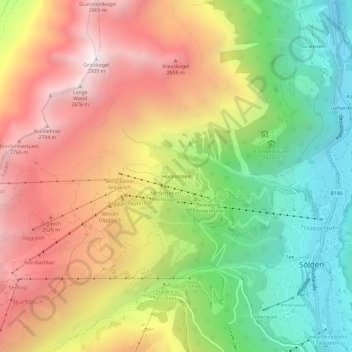
Name: Hochsölden topographic map, elevation, terrain.
Location: Hochsölden, Sölden, Bezirk Imst, Tirol, 6450, Österreich (46.95742 10.96447 46.99742 11.00447)
Average elevation: 6,785 ft
Minimum elevation: 4,268 ft
Maximum elevation: 9,465 ft
Make a donation
Gear up for your next adventure:
As an Amazon Associate, this site earns from qualifying purchases at no extra cost to you.
Other topographic maps
Click on a map to view its topography, its elevation and its terrain.
Rettenbachferner
Österreich > Tirol > Bezirk Imst > Sölden
Er zieht sich von der Inneren Schwarzen Schneid, beziehungsweise dem nördlich davon gelegenen Rettenbachjoch (2990 m, dem Pitztalübergang), bis auf eine Höhe von etwa 2900 Meter hinab. Der Gletscher erreicht derzeit noch eine Länge von etwa einem Kilometer und eine Breite von etwa einem dreiviertel…
Average elevation: 9,567 ft
Vernagtferner
Österreich > Tirol > Bezirk Imst > Sölden
Die Form des sich derzeit in einem Höhenbereich von 3631 bis 2793 m erstreckenden Vernagtferners unterscheidet sich deutlich von der eines typischen alpinen Talgletschers, der beispielsweise der benachbarte Hintereis- oder Kesselwandferner entsprechen. Ein weitausladendes, aus mehreren großen, flachen…
Average elevation: 10,148 ft
Make a donation
Gear up for your next adventure:
As an Amazon Associate, this site earns from qualifying purchases at no extra cost to you.
Guslarferner
Österreich > Tirol > Bezirk Imst > Sölden
Alpinistisch wird der Guslarferner zumeist beim Übergang von der Vernagthütte zum Brandenburger Haus betreten. Dabei steigt man von der Vernagthütte kommend zunächst über die nördliche Randmoräne des Guslarfernes an. Den Gletscher betritt man auf einer Höhe knapp unterhalb 3000 Meter und steigt meist…
Average elevation: 10,141 ft
Gurgler Ferner
Österreich > Tirol > Bezirk Imst > Sölden
Im Jahr 1931 machte der Gurgler Ferner Schlagzeilen, als am 27. Mai der Schweizer Gelehrte Auguste Piccard mit seinem Assistenten Dr. Kipfer nach Aufstellung eines Ballon-Höhenrekords auf dem Gurgler Ferner notlanden musste. Den eigentlichen Ballon konnten Bergsteiger bergen, die schwere Aluminiumgondel…
Average elevation: 9,836 ft
Rotmoosferner
Österreich > Tirol > Bezirk Imst > Sölden
Der Gletscher am Talschluss des Rotmoostals erstreckte sich 2010 in einer Höhenlage von etwa 3400 bis 2400 m und umfasste eine Fläche von rund 3 km². Er fließt vom Gurgler Kamm unterhalb von Liebenerspitze (3399 m ü. A.), Heuflerkogel (3238 m ü. A.) und Trinkerkogel (3160 m ü. A.) rund 3 km nach Norden…
Average elevation: 9,196 ft
Make a donation
Gear up for your next adventure:
As an Amazon Associate, this site earns from qualifying purchases at no extra cost to you.