
Make a donation
Gear up for your next adventure:
As an Amazon Associate, this site earns from qualifying purchases at no extra cost to you.
Barth topographic map
Click on the map to display elevation.
Make a donation
Gear up for your next adventure:
As an Amazon Associate, this site earns from qualifying purchases at no extra cost to you.
Barth
Die Stadtflagge zeigt in drei Längsstreifen unterschiedlicher Breite die Farben Blau–weiß–blau. Die äußeren blauen Streifen nehmen jeweils ein Fünftel, der weiße Mittelstreifen nimmt drei Fünftel der Höhe des Flaggentuchs ein. Auf dem weißen Streifen liegt in der Mitte, die Hälfte der Höhe des Flaggentuchs einnehmend, das Stadtwappen. Die Länge des Flaggentuchs verhält sich zu Höhe wie 3:2.
Make a donation
Gear up for your next adventure:
As an Amazon Associate, this site earns from qualifying purchases at no extra cost to you.
About this map
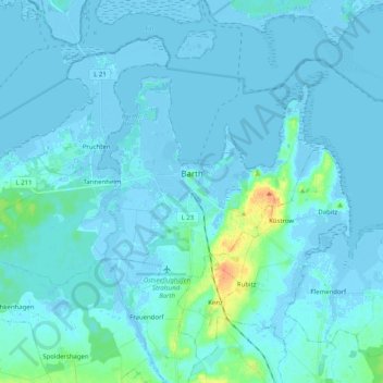
Name: Barth topographic map, elevation, terrain.
Average elevation: 10 ft
Minimum elevation: -20 ft
Maximum elevation: 102 ft
Make a donation
Gear up for your next adventure:
As an Amazon Associate, this site earns from qualifying purchases at no extra cost to you.