Geolocate

Starr topographic map

Click on the map to display elevation.

About this map

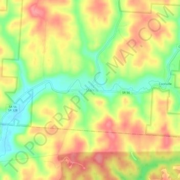
Name: Starr topographic map, elevation, terrain.

Location: Starr, Hocking County, Ohio, 45654, United States (39.37701 -82.38099 39.41701 -82.34099)

Average elevation: 896 ft

Minimum elevation: 735 ft

Maximum elevation: 1,030 ft

Hocking County trails, hiking, mountain biking, running and outdoor activities

Other topographic maps

Click on a map to view its topography, its elevation and its terrain.

Murray City

United States > Ohio > Hocking County

Average elevation: 843 ft

Rose Lake

United States > Ohio > Hocking County

Average elevation: 968 ft

Logan

United States > Ohio > Hocking County

Average elevation: 833 ft

Rose Lake Dam

United States > Ohio > Hocking County

Average elevation: 974 ft

Gear up for your next adventure:

🧥Waterproof Jacket for Hiking - Breathable and rugged rain jacket for outdoor excursions
📻Weather Alert Radios - Stay informed of storm risks while off-the-grid
🧤Hiking Gloves - Protective gloves for rugged trails
☀️Outdoor Sunscreen - High protection sunscreen for outdoor activities
🛠️Backpacking Tool Kit - Essential toolkit for outdoor repairs

As an Amazon Associate, this site earns from qualifying purchases at no extra cost to you.