Geolocate

Greendale topographic map

Click on the map to display elevation.

About this map

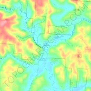
Name: Greendale topographic map, elevation, terrain.

Location: Greendale, Hocking County, Ohio, 43111, United States (39.52201 -82.29543 39.56201 -82.25543)

Average elevation: 817 ft

Minimum elevation: 679 ft

Maximum elevation: 1,017 ft

Hocking County trails, hiking, mountain biking, running and outdoor activities

Other topographic maps

Click on a map to view its topography, its elevation and its terrain.

Murray City

United States > Ohio > Hocking County

Average elevation: 843 ft

Rose Lake

United States > Ohio > Hocking County

Average elevation: 968 ft

Logan

United States > Ohio > Hocking County

Average elevation: 833 ft

Rose Lake Dam

United States > Ohio > Hocking County

Average elevation: 974 ft

Gear up for your next adventure:

📖Nature Tracking Books - Learn to track wildlife and terrain
📡Handheld GPS Device - Reliable handheld GPS for outdoor navigation
🧣Hiking Neck Gaiter - Multi‑use neck protection for outdoor weather
📦Gear Storage Bags - Organize and protect outdoor equipment
🔦Compact Flashlight - Reliable flashlight for emergencies

As an Amazon Associate, this site earns from qualifying purchases at no extra cost to you.