
Thank you for supporting this site ❤️
Make a donation
Make a donation
Gear up for your next adventure:
As an Amazon Associate, this site earns from qualifying purchases at no extra cost to you.
Columbia topographic map
Click on the map to display elevation.
Thank you for supporting this site ❤️
Make a donation
Make a donation
Gear up for your next adventure:
As an Amazon Associate, this site earns from qualifying purchases at no extra cost to you.
About this map
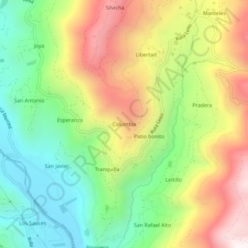
Name: Columbia topographic map, elevation, terrain.
Location: Columbia, Patate, Tungurahua, 180550, Ecuador (-1.36121 -78.50316 -1.32121 -78.46316)
Average elevation: 8,051 ft
Minimum elevation: 6,447 ft
Maximum elevation: 10,174 ft
Thank you for supporting this site ❤️
Make a donation
Make a donation
Gear up for your next adventure:
As an Amazon Associate, this site earns from qualifying purchases at no extra cost to you.