
Budenheim topographic map
Interactive map
Click on the map to display elevation.
About this map
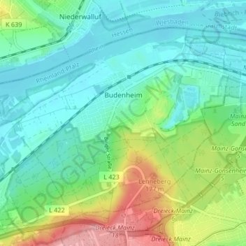
Name: Budenheim topographic map, elevation, terrain.
Average elevation: 371 ft
Minimum elevation: 259 ft
Maximum elevation: 646 ft
Budenheim's greatest elevation is the Lenneberg at 176.8 m, which is in the Lennebergwald. At this spot stands the Lennebergturm (tower), dedicated in 1880 and belonging to the Wander- und Lennebergverein Rheingold Mainz e. V. (a hiking club).
Other topographic maps
Click on a map to view its topography, its elevation and its terrain.
Ingelheim am Rhein
Germany > Rhineland-Palatinate > Landkreis Mainz-Bingen
Ingelheim am Rhein, Landkreis Mainz-Bingen, Rhineland-Palatinate, Germany
Average elevation: 515 ft
Oppenheim
Germany > Rhineland-Palatinate > Landkreis Mainz-Bingen
Oppenheim, Rhein-Selz, Landkreis Mainz-Bingen, Rhineland-Palatinate, 55276, Germany
Average elevation: 397 ft
Nierstein
Germany > Rhineland-Palatinate > Landkreis Mainz-Bingen
Nierstein, Rhein-Selz, Landkreis Mainz-Bingen, Rhineland-Palatinate, 55283, Germany
Average elevation: 407 ft