
Make a donation
Gear up for your next adventure:
As an Amazon Associate, this site earns from qualifying purchases at no extra cost to you.
Valley topographic map
Click on the map to display elevation.
Make a donation
Gear up for your next adventure:
As an Amazon Associate, this site earns from qualifying purchases at no extra cost to you.
Valley
In 1972, the Baltimore and Ohio Railroad was merged into the Chessie System, which planned to close and abandon the South Branch line. The Romney spur through Depot Valley remained in service and was illustrated by the United States Geological Survey on its 1973 Romney Quadrangle topographic map. On October 11, 1978, the Chessie System transferred ownership of the South Branch line to the South Branch Valley Railroad, which in turn was owned and operated by the West Virginia State Rail Authority. During this transition, the Romney spur of the South Branch Valley Railroad was abandoned, after which all rail and commercial activity at Valley ceased.
Make a donation
Gear up for your next adventure:
As an Amazon Associate, this site earns from qualifying purchases at no extra cost to you.
About this map
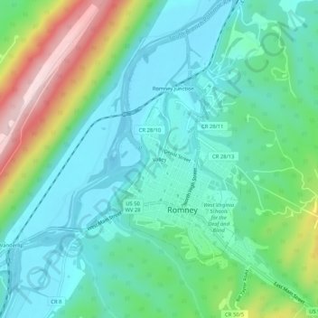
Name: Valley topographic map, elevation, terrain.
Average elevation: 925 ft
Minimum elevation: 627 ft
Maximum elevation: 1,759 ft
Hampshire County trails, hiking, mountain biking, running and outdoor activities
Make a donation
Gear up for your next adventure:
As an Amazon Associate, this site earns from qualifying purchases at no extra cost to you.