Geolocate

Fairhaven topographic map

Click on the map to display elevation.

About this map

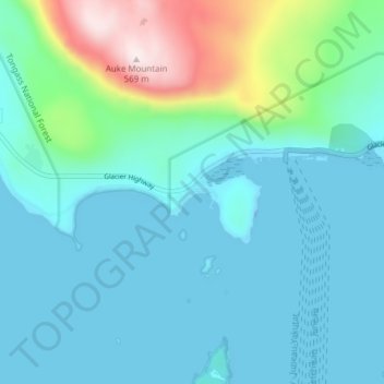
Name: Fairhaven topographic map, elevation, terrain.

Location: Fairhaven, Juneau, Alaska, United States (58.35806 -134.72361 58.39806 -134.68361)

Average elevation: 328 ft

Minimum elevation: -89 ft

Maximum elevation: 1,847 ft

Alaska trails, hiking, mountain biking, running and outdoor activities

Other topographic maps

Click on a map to view its topography, its elevation and its terrain.

Mendenhall Glacier

United States > Alaska > Juneau

Average elevation: 1,178 ft

Lemon Creek

United States > Alaska > Juneau

Average elevation: 1,414 ft

Lena Beach

United States > Alaska > Juneau > Lena Beach

Average elevation: 338 ft

West Juneau

United States > Alaska > Juneau

Average elevation: 361 ft

Gear up for your next adventure:

📶Satellite Messenger - Communication device off‑grid
🥇GPS Hiking Watch - Multi‑sport GPS watch with navigation and trail tracking
🥩Freeze-Dried Meals - Nutritious and lightweight food for remote expeditions
📖Nature Tracking Books - Learn to track wildlife and terrain
🪄Magnetic Compass - Accurate compass for navigation

As an Amazon Associate, this site earns from qualifying purchases at no extra cost to you.