
Thank you for supporting this site ❤️
Make a donation
Make a donation
Gear up for your next adventure:
As an Amazon Associate, this site earns from qualifying purchases at no extra cost to you.
Fontainhas topographic map
Click on the map to display elevation.
Thank you for supporting this site ❤️
Make a donation
Make a donation
Gear up for your next adventure:
As an Amazon Associate, this site earns from qualifying purchases at no extra cost to you.
About this map
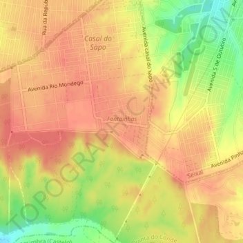
Name: Fontainhas topographic map, elevation, terrain.
Location: Fontainhas, Quinta do Conde, Sesimbra, Setúbal, Portugal (38.54397 -9.08017 38.55099 -9.07169)
Average elevation: 220 ft
Minimum elevation: 92 ft
Maximum elevation: 279 ft
Thank you for supporting this site ❤️
Make a donation
Make a donation
Gear up for your next adventure:
As an Amazon Associate, this site earns from qualifying purchases at no extra cost to you.