Geolocate

Jladri topographic map

Click on the map to display elevation.

About this map

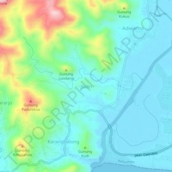
Name: Jladri topographic map, elevation, terrain.

Location: Jladri, Kebumen, Central Java, Java, Indonesia (-7.76101 109.44553 -7.72101 109.48553)

Average elevation: 243 ft

Minimum elevation: -13 ft

Maximum elevation: 1,027 ft

Gear up for your next adventure:

🔥Fast-Boil Camping Stoves - Efficient cooking systems for quick trail meals
🧤Hiking Gloves - Protective gloves for rugged trails
🧺Microfiber Travel Towels - Compact and fast-drying towels for trail use
⛑️Personal Locator Beacon - Safety beacon for emergencies
💧Water Purification System - Clean water on the trail with reliable purifiers

As an Amazon Associate, this site earns from qualifying purchases at no extra cost to you.