Geolocate

Marshfield topographic map

Click on the map to display elevation.

About this map

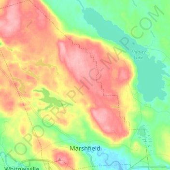
Name: Marshfield topographic map, elevation, terrain.

Location: Marshfield, Washington County, Maine, United States (44.72200 -67.54995 44.80936 -67.43240)

Average elevation: 167 ft

Minimum elevation: -10 ft

Maximum elevation: 358 ft

Washington County trails, hiking, mountain biking, running and outdoor activities

Other topographic maps

Click on a map to view its topography, its elevation and its terrain.

Five Island

United States > Maine > Washington County > Harrington

Average elevation: 112 ft

Gay Hill

United States > Maine > Washington County > Jonesport

Average elevation: 79 ft

Gear up for your next adventure:

🍳Camping Cook Set - Complete cookware for outdoor meals
📶Satellite Messenger - Communication device off‑grid
🌎3D Topographic Globes - Raised relief globes for a tactile understanding of geography
🌄Hiking Binoculars - Compact binoculars for scenic views and trail spotting
🏕️Family Camping Gear - Essentials for group camping trips

As an Amazon Associate, this site earns from qualifying purchases at no extra cost to you.