Geolocate

Nagrak topographic map

Click on the map to display elevation.

About this map

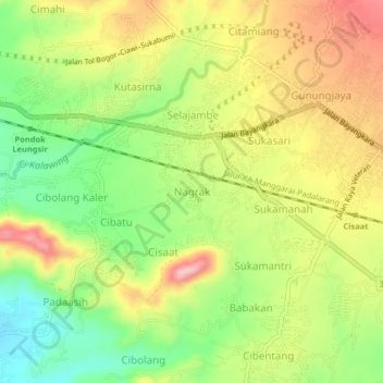
Name: Nagrak topographic map, elevation, terrain.

Location: Nagrak, Sukabumi, West Java, Java, 43152, Indonesia (-6.93158 106.85025 -6.89158 106.89025)

Average elevation: 1,864 ft

Minimum elevation: 1,588 ft

Maximum elevation: 2,162 ft

Other topographic maps

Click on a map to view its topography, its elevation and its terrain.

Cibodas

Indonesia > West Java > Sukabumi > Cimenteng

Average elevation: 853 ft

Cisolok

Indonesia > West Java > Sukabumi

Average elevation: 203 ft

Cikahuripan

Indonesia > West Java > Sukabumi

Average elevation: 361 ft

Gear up for your next adventure:

🧴Hand Sanitizer - Keep hands clean while hiking
🪶Multi‑Purpose Knife - Useful blade for camp and trail
👟Trail Running Shoes - Lightweight shoes for trail runners
🪶Survival Guide Book - Expert advice for emergency preparedness
🔭Telescopic Hiking Pole - Adjustable pole for hiking stability

As an Amazon Associate, this site earns from qualifying purchases at no extra cost to you.