
Thank you for supporting this site ❤️
Make a donation
Make a donation
Gear up for your next adventure:
As an Amazon Associate, this site earns from qualifying purchases at no extra cost to you.
Sabiñán topographic map
Click on the map to display elevation.
Thank you for supporting this site ❤️
Make a donation
Make a donation
Gear up for your next adventure:
As an Amazon Associate, this site earns from qualifying purchases at no extra cost to you.
About this map
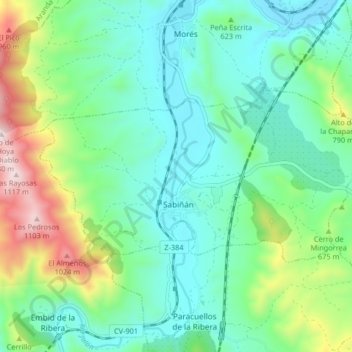
Name: Sabiñán topographic map, elevation, terrain.
Location: Sabiñán, Comunidad de Calatayud, Zaragoza, Aragón, Spanje (41.43351 -1.59922 41.46362 -1.51712)
Average elevation: 1,978 ft
Minimum elevation: 1,368 ft
Maximum elevation: 3,704 ft
Thank you for supporting this site ❤️
Make a donation
Make a donation
Gear up for your next adventure:
As an Amazon Associate, this site earns from qualifying purchases at no extra cost to you.