
Abernathy topographic map
Interactive map
Click on the map to display elevation.
About this map
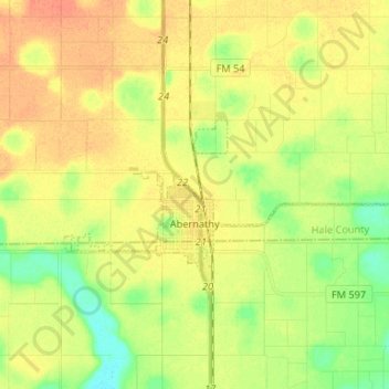
Name: Abernathy topographic map, elevation, terrain.
Location: Abernathy, Hale County, Texas, 79311, United States (33.81949 -101.88752 33.86162 -101.75546)
Average elevation: 3,346 ft
Minimum elevation: 3,281 ft
Maximum elevation: 3,396 ft
Abernathy (elevation 3,360 feet) is located at 33°49′56″N 101°50′35″W / 33.83222°N 101.84306°W / 33.83222; -101.84306 (33.8323038, –101.8429491). Most of the city is located in Hale County; roughly 25% of the city extends southward into Lubbock County.
Other topographic maps
Click on a map to view its topography, its elevation and its terrain.
Lider
United States > Texas > Hale County
Lider, Hale County, Texas, United States
Average elevation: 3,337 ft