Geolocate

Springhills topographic map

Click on the map to display elevation.

About this map

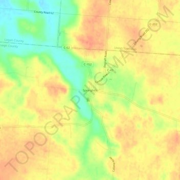
Name: Springhills topographic map, elevation, terrain.

Location: Springhills, Champaign County, Ohio, United States (40.23561 -83.88966 40.27561 -83.84966)

Average elevation: 1,073 ft

Minimum elevation: 974 ft

Maximum elevation: 1,129 ft

Champaign County trails, hiking, mountain biking, running and outdoor activities

Other topographic maps

Click on a map to view its topography, its elevation and its terrain.

North Lewisburg

United States > Ohio > Champaign County

Average elevation: 1,099 ft

Woodstock

United States > Ohio > Champaign County

Average elevation: 1,050 ft

Mutual

United States > Ohio > Champaign County

Average elevation: 1,204 ft

Mechanicsburg

United States > Ohio > Champaign County

Average elevation: 1,089 ft

Mad River

United States > Ohio > Champaign County > West Liberty

Average elevation: 1,106 ft

St. Paris

United States > Ohio > Champaign County

Average elevation: 1,224 ft

Christiansburg

United States > Ohio > Champaign County

Average elevation: 1,122 ft

Gear up for your next adventure:

🌧️Backpack Rain Cover - Keep gear dry in wet weather
GPS Sports Watch - GPS watch for running, hiking and training
🖼️Topo Map Wall Art - Decorative topographic prints of famous peaks and regions
🥾Women's Hiking Boots - Top-rated trail boots with ankle support and superior grip
🔋Solar Power Banks - Keep your GPS and phone charged in remote wilderness areas

As an Amazon Associate, this site earns from qualifying purchases at no extra cost to you.