
Make a donation
Gear up for your next adventure:
As an Amazon Associate, this site earns from qualifying purchases at no extra cost to you.
College Park topographic map
Click on the map to display elevation.
Make a donation
Gear up for your next adventure:
As an Amazon Associate, this site earns from qualifying purchases at no extra cost to you.
About this map
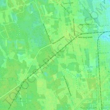
Name: College Park topographic map, elevation, terrain.
Average elevation: 36 ft
Minimum elevation: 10 ft
Maximum elevation: 49 ft
Saint Johns County trails, hiking, mountain biking, running and outdoor activities
Make a donation
Gear up for your next adventure:
As an Amazon Associate, this site earns from qualifying purchases at no extra cost to you.
Other topographic maps
Click on a map to view its topography, its elevation and its terrain.
Castillo de San Marcos
United States > Florida > Saint Johns County > Saint Augustine
Average elevation: 7 ft
Julington Creek Plantation Park
United States > Florida > Saint Johns County > Fruit Cove
Average elevation: 23 ft
Twelve Mile Swamp Conservation Area
United States > Florida > Saint Johns County
Average elevation: 26 ft
Make a donation
Gear up for your next adventure:
As an Amazon Associate, this site earns from qualifying purchases at no extra cost to you.