
Cascob topographic map
Interactive map
Click on the map to display elevation.
About this map
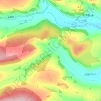
Name: Cascob topographic map, elevation, terrain.
Location: Cascob, Whitton, Powys, Wales, LD8 2NT, United Kingdom (52.27099 -3.13595 52.31099 -3.09595)
Average elevation: 961 ft
Minimum elevation: 587 ft
Maximum elevation: 1,499 ft
Other topographic maps
Click on a map to view its topography, its elevation and its terrain.
Llangunllo
United Kingdom > Wales > Powys > Llangunllo
Llangunllo, Powys, Wales, United Kingdom
Average elevation: 1,089 ft
Black Mountains
United Kingdom > Wales > Powys > Craswall
Black Mountains, Craswall, Powys, Wales, NP7 7NP, United Kingdom
Average elevation: 1,224 ft
Heol-fanog
United Kingdom > Wales > Powys
Heol-fanog, Glyn Tarell, Powys, Wales, LD3 8LE, United Kingdom
Average elevation: 971 ft
Welshpool
United Kingdom > Wales > Powys
Welshpool, Powys, Wales, SY21 7SD, United Kingdom
Average elevation: 512 ft