
Bulisa topographic map
Click on the map to display elevation.
Bulisa
Buliisa is located in the northwestern corner of Buliisa District, along the shores of Lake Albert, approximately 91 kilometres (57 mi), by road, north of Hoima, the largest city in the Bunyoro sub-region. This is approximately 299 kilometres (186 mi), by road, northwest of Kampala, Uganda's capital and largest city. The geographical coordinates of Buliisa Town are:02°07'18.0"N, 31°24'56.0"E (Latitude:2.121667; Longitude:31.415556). The town sits at an average elevation of 627 metres (2,057 ft) above mean sea level.
About this map
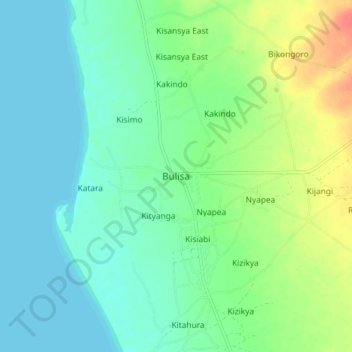
Name: Bulisa topographic map, elevation, terrain.
Location: Bulisa, Buliisa, Western Region, Uganda (2.07803 31.37152 2.15803 31.45152)
Average elevation: 2,064 ft
Minimum elevation: 2,018 ft
Maximum elevation: 2,178 ft