
Thank you for supporting this site ❤️
Make a donation
Make a donation
Gear up for your next adventure:
As an Amazon Associate, this site earns from qualifying purchases at no extra cost to you.
Nesari topographic map
Click on the map to display elevation.
Thank you for supporting this site ❤️
Make a donation
Make a donation
Gear up for your next adventure:
As an Amazon Associate, this site earns from qualifying purchases at no extra cost to you.
About this map
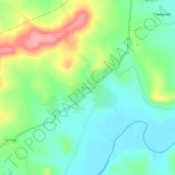
Name: Nesari topographic map, elevation, terrain.
Location: Nesari, Gadhinglaj, Kolhapur, Maharashtra, 416504, India (16.03801 74.30322 16.07801 74.34322)
Average elevation: 2,395 ft
Minimum elevation: 2,270 ft
Maximum elevation: 2,644 ft
Thank you for supporting this site ❤️
Make a donation
Make a donation
Gear up for your next adventure:
As an Amazon Associate, this site earns from qualifying purchases at no extra cost to you.