
Make a donation
Gear up for your next adventure:
As an Amazon Associate, this site earns from qualifying purchases at no extra cost to you.
Comuna 7 - Robledo topographic map
Click on the map to display elevation.
Make a donation
Gear up for your next adventure:
As an Amazon Associate, this site earns from qualifying purchases at no extra cost to you.
Comuna 7 - Robledo
El área total de Robledo es de unos 938.22 hectáreas, presenta una topografía quebrada, especialmente hacia el occidente, predominando las pendientes entre el 13.0% y el 36.0%. Se destaca el Cerro El Volador como el más importante accidente geográfico, además de ser un punto de referencia a nivel de la Comuna y de la ciudad.
Make a donation
Gear up for your next adventure:
As an Amazon Associate, this site earns from qualifying purchases at no extra cost to you.
About this map
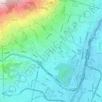
Name: Comuna 7 - Robledo topographic map, elevation, terrain.
Average elevation: 5,407 ft
Minimum elevation: 4,724 ft
Maximum elevation: 8,117 ft
Make a donation
Gear up for your next adventure:
As an Amazon Associate, this site earns from qualifying purchases at no extra cost to you.
Other topographic maps
Click on a map to view its topography, its elevation and its terrain.
Make a donation
Gear up for your next adventure:
As an Amazon Associate, this site earns from qualifying purchases at no extra cost to you.
Parque del Barrio Alfonso Lopez
Colombia > Antioquia > Perímetro Urbano Medellín
Average elevation: 5,079 ft
Parque Biblioteca Presbítero José Luis Arroyave - San Javier
Colombia > Antioquia > Perímetro Urbano Medellín
Average elevation: 5,203 ft
Make a donation
Gear up for your next adventure:
As an Amazon Associate, this site earns from qualifying purchases at no extra cost to you.