
Erastus topographic map
Click on the map to display elevation.
About this map
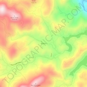
Name: Erastus topographic map, elevation, terrain.
Location: Erastus, Jackson County, North Carolina, United States (35.17076 -83.20761 35.21076 -83.16761)
Average elevation: 3,806 ft
Minimum elevation: 2,815 ft
Maximum elevation: 4,649 ft
Jackson County trails, hiking, mountain biking, running and outdoor activities
Other topographic maps
Click on a map to view its topography, its elevation and its terrain.
Wolftown Community
United States > North Carolina > Jackson County > Wolftown Community
Average elevation: 3,665 ft
Panthertown Valley Backcountry Area
United States > North Carolina > Jackson County
Average elevation: 3,671 ft