
Make a donation
Gear up for your next adventure:
As an Amazon Associate, this site earns from qualifying purchases at no extra cost to you.
Westenholz topographic map
Click on the map to display elevation.
Make a donation
Gear up for your next adventure:
As an Amazon Associate, this site earns from qualifying purchases at no extra cost to you.
About this map
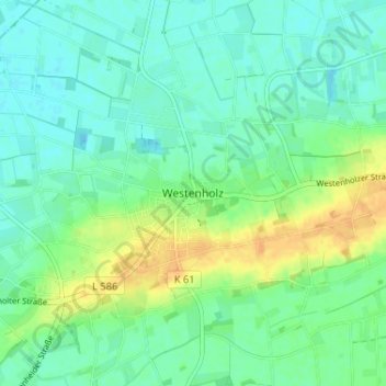
Name: Westenholz topographic map, elevation, terrain.
Average elevation: 282 ft
Minimum elevation: 249 ft
Maximum elevation: 344 ft
Make a donation
Gear up for your next adventure:
As an Amazon Associate, this site earns from qualifying purchases at no extra cost to you.
Other topographic maps
Click on a map to view its topography, its elevation and its terrain.
Anreppen
Deutschland > Nordrhein-Westfalen > Kreis Paderborn > Delbrück
Anreppen liegt im südöstlichen Winkel der Westfälischen Bucht direkt nördlich der Lippe bei 51° 45′ n. Br., 8° 34′ ö. L. auf einer Höhe von 90 m ü. NN. Laut der heute meist benutzten Einteilung im Handbuch der naturräumlichen Gliederung Deutschlands liegt der Ort in der Untereinheit 540.20 Obere…
Average elevation: 302 ft
Ostenland
Deutschland > Nordrhein-Westfalen > Kreis Paderborn > Delbrück > Wittendorf
Average elevation: 331 ft
Boke
Deutschland > Nordrhein-Westfalen > Kreis Paderborn > Delbrück
Boke gehört wie Ostwestfalen-Lippe insgesamt zum ozeanischen Klimabereich Nordwestdeutschlands, dem es geringe Temperaturgegensätze und milde Winter verdankt. Allerdings sind schon kontinentale Einflüsse wirksam. So liegt die Temperatur im Sommer höher und die Nächte sind kühler als in größerer Nähe…
Average elevation: 295 ft
Make a donation
Gear up for your next adventure:
As an Amazon Associate, this site earns from qualifying purchases at no extra cost to you.