
Make a donation
Gear up for your next adventure:
As an Amazon Associate, this site earns from qualifying purchases at no extra cost to you.
Camiguin topographic map
Click on the map to display elevation.
Make a donation
Gear up for your next adventure:
As an Amazon Associate, this site earns from qualifying purchases at no extra cost to you.
Camiguin
Camiguin Island is a pearl-shaped island with an area of approximately 238 square kilometers (92 sq mi). The island measures about 23 kilometers (14 mi) at its longest and 14.5 kilometers (9.0 mi) at its widest breadth. The island is mountainous with the highest elevation reaching over 5,000 ft (1,500 m). It is encircled by a national road with a length of about 64 kilometers (40 mi). As of the August 1, 2007, census, the province has a fifth-class income classification with a population of 81,293.
Make a donation
Gear up for your next adventure:
As an Amazon Associate, this site earns from qualifying purchases at no extra cost to you.
About this map
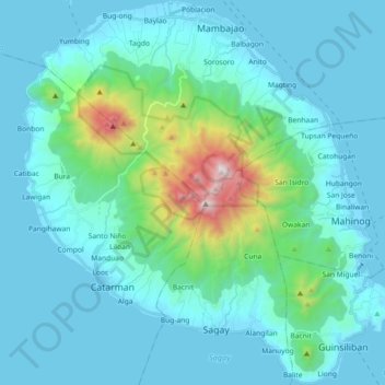
Name: Camiguin topographic map, elevation, terrain.
Location: Camiguin, Northern Mindanao, Philippines (9.07872 124.63333 9.25822 124.80644)
Average elevation: 679 ft
Minimum elevation: -7 ft
Maximum elevation: 5,262 ft
Make a donation
Gear up for your next adventure:
As an Amazon Associate, this site earns from qualifying purchases at no extra cost to you.
Other topographic maps
Click on a map to view its topography, its elevation and its terrain.
Mount Hibok-Hibok
Philippines > Camiguin > Catarman
Volcanologists classify Hibok-Hibok or Catarman Volcano as a stratovolcano and dome complex with an elevation of 1,332 metres (4,370 ft) and a base diameter of 10 kilometres (6.2 mi). It was described in a 1905 report as having "suddenly risen from the plain a short distance from the town of Catarmin in 1872.
Average elevation: 2,720 ft