
Make a donation
Gear up for your next adventure:
As an Amazon Associate, this site earns from qualifying purchases at no extra cost to you.
Fischenich topographic map
Click on the map to display elevation.
Make a donation
Gear up for your next adventure:
As an Amazon Associate, this site earns from qualifying purchases at no extra cost to you.
Fischenich
Am Villehang gelegen, differiert die Höhenlage der Ortschaft zwischen 80 und 130 m über NN. Die alten Höfe am Quellhorizont bewirtschafteten ihre Felder in der vorgelagerten Kölner Bucht. Bis jetzt ist der Ort noch sehr bäuerlich geprägt.
Make a donation
Gear up for your next adventure:
As an Amazon Associate, this site earns from qualifying purchases at no extra cost to you.
About this map
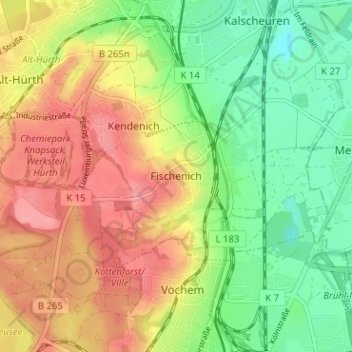
Name: Fischenich topographic map, elevation, terrain.
Average elevation: 282 ft
Minimum elevation: 144 ft
Maximum elevation: 427 ft
Make a donation
Gear up for your next adventure:
As an Amazon Associate, this site earns from qualifying purchases at no extra cost to you.