
Fraineux topographic map
Interactive map
Click on the map to display elevation.
About this map
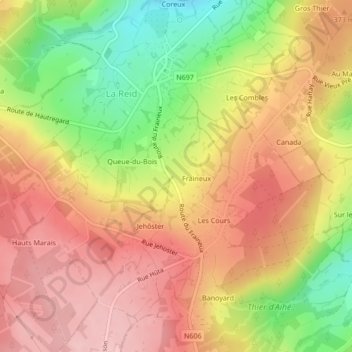
Name: Fraineux topographic map, elevation, terrain.
Location: Fraineux, La Reid, Theux, Luik, Wallonië, 4910, België (50.47122 5.78244 50.49122 5.80244)
Average elevation: 1,138 ft
Minimum elevation: 817 ft
Maximum elevation: 1,358 ft
Other topographic maps
Click on a map to view its topography, its elevation and its terrain.
Hautregard
België > Wallonië > Theux > Hautregard
Hautregard, La Reid, Theux, Luik, Wallonië, 4910, België
Average elevation: 1,076 ft