
Hoëgne topographic map
Interactive map
Click on the map to display elevation.
About this map
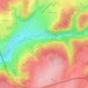
Name: Hoëgne topographic map, elevation, terrain.
Location: Hoëgne, Theux, Verviers, Luik, Wallonië, 4910, België (50.53488 5.87607 50.54307 5.91787)
Average elevation: 1,007 ft
Minimum elevation: 699 ft
Maximum elevation: 1,224 ft
Other topographic maps
Click on a map to view its topography, its elevation and its terrain.
Hautregard
België > Wallonië > Theux > Hautregard
Hautregard, La Reid, Theux, Luik, Wallonië, 4910, België
Average elevation: 1,076 ft