
Make a donation
Gear up for your next adventure:
As an Amazon Associate, this site earns from qualifying purchases at no extra cost to you.
Altenseelbach topographic map
Click on the map to display elevation.
Make a donation
Gear up for your next adventure:
As an Amazon Associate, this site earns from qualifying purchases at no extra cost to you.
About this map
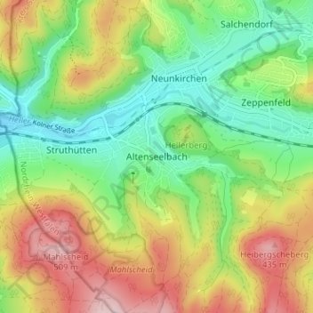
Name: Altenseelbach topographic map, elevation, terrain.
Average elevation: 1,148 ft
Minimum elevation: 801 ft
Maximum elevation: 1,644 ft
Make a donation
Gear up for your next adventure:
As an Amazon Associate, this site earns from qualifying purchases at no extra cost to you.
Other topographic maps
Click on a map to view its topography, its elevation and its terrain.
Niederndorf
Deutschland > Nordrhein-Westfalen > Kreis Siegen-Wittgenstein > Freudenberg
Average elevation: 1,030 ft
Hainchen
Deutschland > Nordrhein-Westfalen > Kreis Siegen-Wittgenstein > Netphen
Hainchen liegt am Ostrand des historischen Siegerlandes, an der Nahtstelle der Quellmuldenlandschaft des naturräumlichen Siegerlandes zum Rothaargebirge. Die nach dem Ort benannte Haincher Höhe, die die Ortslage unmittelbar östlich um rund 200 m überragt, stellt einen gratartigen Südwestausläufer des…
Average elevation: 1,591 ft