
Make a donation
Gear up for your next adventure:
As an Amazon Associate, this site earns from qualifying purchases at no extra cost to you.
Oliverea topographic map
Click on the map to display elevation.
Make a donation
Gear up for your next adventure:
As an Amazon Associate, this site earns from qualifying purchases at no extra cost to you.
About this map
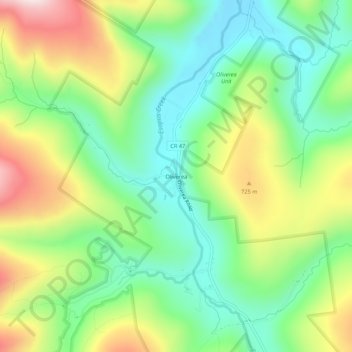
Name: Oliverea topographic map, elevation, terrain.
Average elevation: 1,939 ft
Minimum elevation: 1,299 ft
Maximum elevation: 3,009 ft
Ulster County trails, hiking, mountain biking, running and outdoor activities
Make a donation
Gear up for your next adventure:
As an Amazon Associate, this site earns from qualifying purchases at no extra cost to you.
Other topographic maps
Click on a map to view its topography, its elevation and its terrain.
Slide Mountain Wilderness
United States > New York > Ulster County > Town of Shandaken > Town of Denning
Within its boundaries lie 10 of the 35 Catskill High Peaks, including the highest Catskill peak, Slide, 4,180 feet (1277 m) of elevation; and lowest, Rocky.
Average elevation: 1,916 ft
Big Indian Park
United States > New York > Ulster County > Town of Shandaken > Big Indian
Average elevation: 1,617 ft
Glenbrook Park
United States > New York > Ulster County > Town of Shandaken
Average elevation: 1,499 ft