
Make a donation
Gear up for your next adventure:
As an Amazon Associate, this site earns from qualifying purchases at no extra cost to you.
Machu Picchu topographic map
Click on the map to display elevation.
Make a donation
Gear up for your next adventure:
As an Amazon Associate, this site earns from qualifying purchases at no extra cost to you.
Machu Picchu
Animals are also suspected to have immigrated to Machu Picchu as there were several bones found that were not native to the area. Most animal bones found were from llamas and alpacas. These animals naturally live at altitudes of 4,000 metres (13,000 ft) rather than the 2,400 metres (7,900 ft) elevation of Machu Picchu. Most likely, these animals were brought in from the Puna region for meat consumption and for their pelts. Guinea pigs were also found at the site in special burial caves, suggesting that they were at least used for funerary rituals, as it was common throughout the Inca Empire to use them for sacrifices and meat. Six dogs were also recovered from the site. Due to their placements among the human remains, it is believed that they served as companions of the dead.
Make a donation
Gear up for your next adventure:
As an Amazon Associate, this site earns from qualifying purchases at no extra cost to you.
About this map
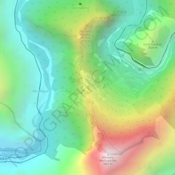
Name: Machu Picchu topographic map, elevation, terrain.
Average elevation: 7,306 ft
Minimum elevation: 5,817 ft
Maximum elevation: 9,944 ft
Make a donation
Gear up for your next adventure:
As an Amazon Associate, this site earns from qualifying purchases at no extra cost to you.