
Make a donation
Gear up for your next adventure:
As an Amazon Associate, this site earns from qualifying purchases at no extra cost to you.
Höfen topographic map
Click on the map to display elevation.
Make a donation
Gear up for your next adventure:
As an Amazon Associate, this site earns from qualifying purchases at no extra cost to you.
Höfen
Der Ort liegt am Rand des Nationalpark Eifel, im Ort befindet sich eines der fünf Nationalpark-Tore. Charakteristisch für Höfen sind die haushohen Rotbuchenhecken; der Ort ist ein gutes Dokumentationsbeispiel für das Monschauer Heckenland. Höfen liegt eifeltypisch auf der Höhe. Die bis zu 10 m hohen Hecken schützen vor den heftigen Winden und verhindern so im Winter das Auskühlen des dahinter liegenden Hauses. Buchenhecken verlieren ihr welkes Laub erst im Frühjahr, mit dem Neuaustrieb.
Make a donation
Gear up for your next adventure:
As an Amazon Associate, this site earns from qualifying purchases at no extra cost to you.
About this map
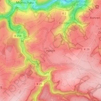
Name: Höfen topographic map, elevation, terrain.
Average elevation: 1,722 ft
Minimum elevation: 1,253 ft
Maximum elevation: 1,913 ft
Make a donation
Gear up for your next adventure:
As an Amazon Associate, this site earns from qualifying purchases at no extra cost to you.
Other topographic maps
Click on a map to view its topography, its elevation and its terrain.
Troisdorfer Weiher
Deutschland > Nordrhein-Westfalen > Städteregion Aachen > Monschau > Konzen
Average elevation: 1,791 ft
Kalltal
Deutschland > Nordrhein-Westfalen > Städteregion Aachen > Monschau > Entenpfuhl
Average elevation: 1,811 ft