
Roi Et Province topographic map
Interactive map
Click on the map to display elevation.
About this map
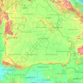
Name: Roi Et Province topographic map, elevation, terrain.
Location: Roi Et Province, Thailand (13.18864 101.14130 18.30864 106.26130)
Average elevation: 728 ft
Minimum elevation: 0 ft
Maximum elevation: 7,054 ft
Other topographic maps
Click on a map to view its topography, its elevation and its terrain.
At Samat
Thailand > Roi Et Province > At Samat
At Samat, Roi Et Province, 45160, Thailand
Average elevation: 449 ft
Ban Chan
Thailand > Roi Et Province > Ban Chan
Ban Chan, Roi Et Province, Thailand
Average elevation: 436 ft