
Make a donation
Gear up for your next adventure:
As an Amazon Associate, this site earns from qualifying purchases at no extra cost to you.
Bouillon topographic map
Click on the map to display elevation.
Make a donation
Gear up for your next adventure:
As an Amazon Associate, this site earns from qualifying purchases at no extra cost to you.
Bouillon
De dorpskernen van Bouillon, Poupehan en Frahan (in de deelgemeente Rochehaut) liggen elk op een meander van de Semois. Bouillon is verder bekend vanwege de Tombeau du Géant ('graf van de reus'), een quasi onbewoonde maar beboste meander in de Semois bij Botassart in Ucimont, die zijn naam dankt aan het feit dat de bomen op het min of meer grafvormige schiereiland 's winters een groot kruis vormen. Het stadscentrum van Bouillon is door de Semois van de steile, beboste helling Côte d'Auclin (met daarop de uitzichttoren Belvédère) gescheiden. Bouillon ligt op een hoogte van 383 meter boven de zeespiegel (TAW) en wordt kloksgewijs begrensd door Paliseul, Bertrix, Florenville (arrondissement Virton), Frankrijk, Vresse-sur-Semois en Bièvre (beide in Namen).
Make a donation
Gear up for your next adventure:
As an Amazon Associate, this site earns from qualifying purchases at no extra cost to you.
About this map
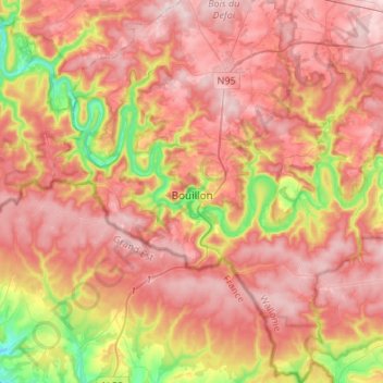
Name: Bouillon topographic map, elevation, terrain.
Location: Bouillon, Neufchâteau, Luxemburg, Wallonië, België (49.70920 4.96855 49.88368 5.18961)
Average elevation: 1,122 ft
Minimum elevation: 551 ft
Maximum elevation: 1,493 ft
Make a donation
Gear up for your next adventure:
As an Amazon Associate, this site earns from qualifying purchases at no extra cost to you.
Other topographic maps
Click on a map to view its topography, its elevation and its terrain.
Région Famenne et Calestienne
België > Luxemburg > Neufchâteau > Saint-Hubert
Average elevation: 1,178 ft
Make a donation
Gear up for your next adventure:
As an Amazon Associate, this site earns from qualifying purchases at no extra cost to you.
Make a donation
Gear up for your next adventure:
As an Amazon Associate, this site earns from qualifying purchases at no extra cost to you.
Make a donation
Gear up for your next adventure:
As an Amazon Associate, this site earns from qualifying purchases at no extra cost to you.
Make a donation
Gear up for your next adventure:
As an Amazon Associate, this site earns from qualifying purchases at no extra cost to you.
Make a donation
Gear up for your next adventure:
As an Amazon Associate, this site earns from qualifying purchases at no extra cost to you.
Fourneau Saint-Michel
België > Luxemburg > Neufchâteau > Saint-Hubert
Op een open plek in het bos staan twee musea die gewijd zijn aan het leven in het verleden van deze streek. De laatste abt van de Sint-Hubertusabdij, Nicolas Spirlet (1715-1794), richtte hier in 1771 een ijzergieterij en hoogoven in bij de Masbelette. Nadat in het vervolg van de Franse Revolutie de kerkelijke…
Average elevation: 1,283 ft
Make a donation
Gear up for your next adventure:
As an Amazon Associate, this site earns from qualifying purchases at no extra cost to you.
Make a donation
Gear up for your next adventure:
As an Amazon Associate, this site earns from qualifying purchases at no extra cost to you.
Bonance
België > Luxemburg > Neufchâteau > Libramont > Libramont-Chevigny > Bonance
Average elevation: 1,637 ft
Make a donation
Gear up for your next adventure:
As an Amazon Associate, this site earns from qualifying purchases at no extra cost to you.