
Make a donation
Gear up for your next adventure:
As an Amazon Associate, this site earns from qualifying purchases at no extra cost to you.
Pignia topographic map
Click on the map to display elevation.
Make a donation
Gear up for your next adventure:
As an Amazon Associate, this site earns from qualifying purchases at no extra cost to you.
About this map
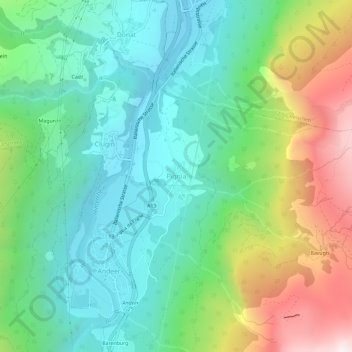
Name: Pignia topographic map, elevation, terrain.
Location: Pignia, Andeer, Viamala, Graubünden, 7443, Schweiz (46.59305 9.41813 46.63305 9.45813)
Average elevation: 4,596 ft
Minimum elevation: 3,038 ft
Maximum elevation: 8,077 ft
Make a donation
Gear up for your next adventure:
As an Amazon Associate, this site earns from qualifying purchases at no extra cost to you.
Other topographic maps
Click on a map to view its topography, its elevation and its terrain.
Mutten
Schweiz > Graubünden > Viamala
Mutten ist eine Siedlung der deutschsprachigen Walser inmitten von bündnerromanischen Gemeinden. Es ist denkbar, dass die Siedlung im 14. Jahrhundert von den Freiherren von Vaz angelegt worden ist, um den schmalen Passstreifen zwischen deren Besitzungen im Schams und im Albulatal zu sichern. Der Ortsname…
Average elevation: 5,440 ft
Make a donation
Gear up for your next adventure:
As an Amazon Associate, this site earns from qualifying purchases at no extra cost to you.