
Thank you for supporting this site ❤️
Make a donation
Make a donation
Gear up for your next adventure:
As an Amazon Associate, this site earns from qualifying purchases at no extra cost to you.
Taluka topographic map
Click on the map to display elevation.
Thank you for supporting this site ❤️
Make a donation
Make a donation
Gear up for your next adventure:
As an Amazon Associate, this site earns from qualifying purchases at no extra cost to you.
About this map
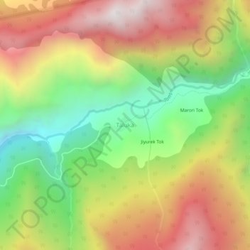
Name: Taluka topographic map, elevation, terrain.
Location: Taluka, Mori, Uttarkashi, Uttarakhand, India (31.05782 78.22579 31.09782 78.26579)
Average elevation: 8,166 ft
Minimum elevation: 5,915 ft
Maximum elevation: 10,551 ft
Thank you for supporting this site ❤️
Make a donation
Make a donation
Gear up for your next adventure:
As an Amazon Associate, this site earns from qualifying purchases at no extra cost to you.