
Make a donation
Gear up for your next adventure:
As an Amazon Associate, this site earns from qualifying purchases at no extra cost to you.
Ovronnaz topographic map
Click on the map to display elevation.
Make a donation
Gear up for your next adventure:
As an Amazon Associate, this site earns from qualifying purchases at no extra cost to you.
About this map
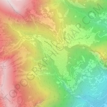
Name: Ovronnaz topographic map, elevation, terrain.
Location: Ovronnaz, Leytron, Martinach, Wallis, 1911, Schweiz (46.17898 7.15234 46.21898 7.19234)
Average elevation: 4,485 ft
Minimum elevation: 1,535 ft
Maximum elevation: 7,513 ft
Make a donation
Gear up for your next adventure:
As an Amazon Associate, this site earns from qualifying purchases at no extra cost to you.
Other topographic maps
Click on a map to view its topography, its elevation and its terrain.
Riddes
Gegen Süden erstreckt sich das Gemeindegebiet von der Rhonetalebene auf 471 m. ü. M. über den steilen Berghang bis hinauf an die Bergkette von Savoleyres, Mont Rogneux und Mont Gelé, der mit der Höhe von 3023 m. ü. M. den höchsten Punkt der Gemeinde bildet. Im Hochgebirge liegt unterhalb des Mont Gelé…
Average elevation: 4,626 ft
Make a donation
Gear up for your next adventure:
As an Amazon Associate, this site earns from qualifying purchases at no extra cost to you.