Geolocate

Rogojel topographic map

Click on the map to display elevation.

About this map

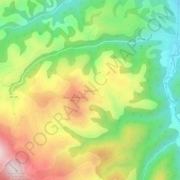
Name: Rogojel topographic map, elevation, terrain.

Location: Rogojel, Săcuieu, Cluj, 407496, Romania (46.77265 22.84104 46.81265 22.88104)

Average elevation: 2,933 ft

Minimum elevation: 2,044 ft

Maximum elevation: 4,114 ft

Other topographic maps

Click on a map to view its topography, its elevation and its terrain.

Gilău

Romania > Cluj

Average elevation: 1,434 ft

Apahida

Romania > Cluj

Average elevation: 1,260 ft

Mărișel

Romania > Cluj

Average elevation: 3,776 ft

Gherla

Romania > Cluj > Gherla

Average elevation: 1,129 ft

Câmpia Turzii

Romania > Cluj > Câmpia Turzii

Average elevation: 1,027 ft

Gear up for your next adventure:

🥄Camping Utensil Set - Lightweight utensils for outdoor meals
🪓Survival Multi‑Tool - Versatile tool for camp and trail tasks
🔥Camping Stove - Portable stove for camping and backcountry cooking
🧴Hand Sanitizer - Keep hands clean while hiking
🔭Stargazing Telescopes - Perfect for camping in low-light pollution areas shown on maps

As an Amazon Associate, this site earns from qualifying purchases at no extra cost to you.