
Bilbao topographic map
Click on the map to display elevation.
Bilbao
Bilbao is situated in the north-central part of Spain, some 16 kilometres (10 mi) south of the Bay of Biscay, where the economic social development is located, where the estuary of Bilbao is formed. Its main urban core is surrounded by two small mountain ranges with an average elevation of 400 metres (1,300 ft). Its climate is shaped by the Bay of Biscay low-pressure systems and mild air, moderating summer temperatures by Iberian standards, with low sunshine and high rainfall. The annual temperature range is low for its latitude.
About this map
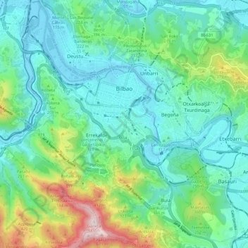
Name: Bilbao topographic map, elevation, terrain.
Location: Bilbao, Greater Bilbao, Biscay, Basque Country, Spain (43.21372 -2.98598 43.29013 -2.88026)
Average elevation: 512 ft
Minimum elevation: -7 ft
Maximum elevation: 2,211 ft