Geolocate

Varshets topographic map

Click on the map to display elevation.

About this map

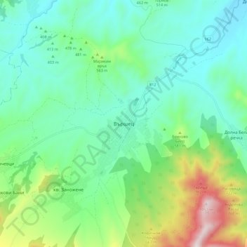
Name: Varshets topographic map, elevation, terrain.

Location: Varshets, Montana, Bulgaria (43.15925 23.24940 43.23925 23.32940)

Average elevation: 1,535 ft

Minimum elevation: 876 ft

Maximum elevation: 3,451 ft

Other topographic maps

Click on a map to view its topography, its elevation and its terrain.

Berkovitsa

Bulgaria > Montana

Average elevation: 2,454 ft

Varshets

Bulgaria > Montana

Average elevation: 2,411 ft

Gear up for your next adventure:

🗺️NatGeo Topo Maps - High-quality waterproof printed topographic maps of US Parks
🪶Fire Starter Kit - Reliable fire starter for survival and camping
🪶Survival Guide Book - Expert advice for emergency preparedness
🔭Compact Binoculars - HD vision for scouting terrain and identifying distant landmarks
🏕️Family Camping Gear - Essentials for group camping trips

As an Amazon Associate, this site earns from qualifying purchases at no extra cost to you.