
Thank you for supporting this site ❤️
Make a donation
Make a donation
Gear up for your next adventure:
As an Amazon Associate, this site earns from qualifying purchases at no extra cost to you.
Parwanoo topographic map
Click on the map to display elevation.
Thank you for supporting this site ❤️
Make a donation
Make a donation
Gear up for your next adventure:
As an Amazon Associate, this site earns from qualifying purchases at no extra cost to you.
About this map
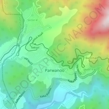
Name: Parwanoo topographic map, elevation, terrain.
Location: Parwanoo, Kasauli, Solan, Himachal Pradesh, 173220, India (30.82751 76.94496 30.85676 76.97515)
Average elevation: 2,828 ft
Minimum elevation: 1,969 ft
Maximum elevation: 4,596 ft
Thank you for supporting this site ❤️
Make a donation
Make a donation
Gear up for your next adventure:
As an Amazon Associate, this site earns from qualifying purchases at no extra cost to you.