
Make a donation
Gear up for your next adventure:
As an Amazon Associate, this site earns from qualifying purchases at no extra cost to you.
Courcelles topographic map
Click on the map to display elevation.
Make a donation
Gear up for your next adventure:
As an Amazon Associate, this site earns from qualifying purchases at no extra cost to you.
About this map
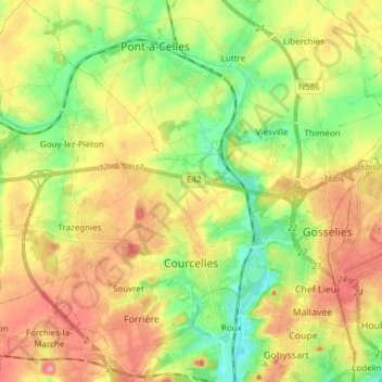
Name: Courcelles topographic map, elevation, terrain.
Location: Courcelles, Charleroi, Henegouwen, Wallonië, 6180, België (50.42743 4.28696 50.52383 4.40520)
Average elevation: 495 ft
Minimum elevation: 341 ft
Maximum elevation: 666 ft
Make a donation
Gear up for your next adventure:
As an Amazon Associate, this site earns from qualifying purchases at no extra cost to you.
Other topographic maps
Click on a map to view its topography, its elevation and its terrain.
Charleroi
België > Henegouwen > Charleroi > Charleroi
Met forse subsidies (onder andere 750 miljoen euro van de Europese Unie voor de provincie Henegouwen) probeert het Waals Gewest het tij te keren, door nieuwe bedrijven aan te trekken. Zo kent de luchthaven van Charleroi (deelgemeente Gosselies) die jarenlang een sluimerend bestaan leidde, sinds 2001 toen de…
Average elevation: 558 ft