Geolocate

Lesce topographic map

Click on the map to display elevation.

About this map

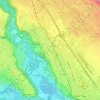
Name: Lesce topographic map, elevation, terrain.

Location: Lesce, Radovljica, 4248, Slovenia (46.34180 14.13444 46.38180 14.17444)

Average elevation: 1,598 ft

Minimum elevation: 1,339 ft

Maximum elevation: 1,916 ft

Gear up for your next adventure:

🔋Rechargeable Batteries - Power up your outdoor devices
🪑Portable Camp Table - Compact table for campsite meals
📦Gear Storage Bags - Organize and protect outdoor equipment
📻Weather Alert Radios - Stay informed of storm risks while off-the-grid
🔥Plasma Lighters - Windproof lighters that work in any weather condition

As an Amazon Associate, this site earns from qualifying purchases at no extra cost to you.