
Make a donation
Gear up for your next adventure:
As an Amazon Associate, this site earns from qualifying purchases at no extra cost to you.
Gangolihāt topographic map
Click on the map to display elevation.
Make a donation
Gear up for your next adventure:
As an Amazon Associate, this site earns from qualifying purchases at no extra cost to you.
Gangolihāt
Gangolihat is located at 29°29′N 80°03′E / 29.48°N 80.05°E / 29.48; 80.05. It has an average elevation of 1,760 metres (5,773 feet). It is 78 km from Pithoragarh. The main town is at a hill top. The region is surrounded by two rivers Saryu and Ramganga. Which meet at Ghat at the foothill of the region. These two rivers make it like a Garland on the shoulders of mighty Himalaya. These two rivers gave the name to the region Gang (River in Kumaoni) + Awali (Garland) making Gangawali which became Gangoli later on. and Hat were the main markets/ gathering place for local people in past. Which made the name of Gangolihat.
Make a donation
Gear up for your next adventure:
As an Amazon Associate, this site earns from qualifying purchases at no extra cost to you.
About this map
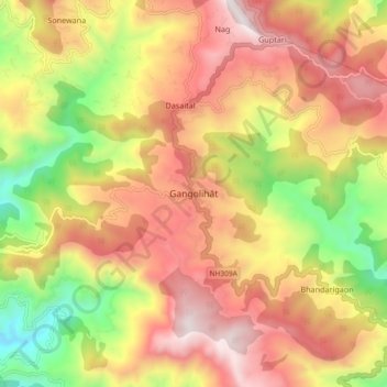
Name: Gangolihāt topographic map, elevation, terrain.
Average elevation: 5,026 ft
Minimum elevation: 2,592 ft
Maximum elevation: 7,077 ft
Make a donation
Gear up for your next adventure:
As an Amazon Associate, this site earns from qualifying purchases at no extra cost to you.