
Thank you for supporting this site ❤️
Make a donation
Make a donation
Gear up for your next adventure:
As an Amazon Associate, this site earns from qualifying purchases at no extra cost to you.
Rigoli topographic map
Click on the map to display elevation.
Thank you for supporting this site ❤️
Make a donation
Make a donation
Gear up for your next adventure:
As an Amazon Associate, this site earns from qualifying purchases at no extra cost to you.
About this map
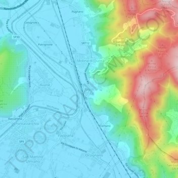
Name: Rigoli topographic map, elevation, terrain.
Location: Rigoli, San Giuliano Terme, Pisa, Toscana, 56017, Italia (43.76865 10.40238 43.80865 10.44238)
Average elevation: 361 ft
Minimum elevation: 0 ft
Maximum elevation: 1,493 ft
Thank you for supporting this site ❤️
Make a donation
Make a donation
Gear up for your next adventure:
As an Amazon Associate, this site earns from qualifying purchases at no extra cost to you.