
Make a donation
Gear up for your next adventure:
As an Amazon Associate, this site earns from qualifying purchases at no extra cost to you.
Estavayer-le-Lac topographic map
Click on the map to display elevation.
Make a donation
Gear up for your next adventure:
As an Amazon Associate, this site earns from qualifying purchases at no extra cost to you.
Estavayer-le-Lac
The municipality is located in the Broye district, on the southern bank of Lake Neuchatel at an elevation of 430 to 460 meters (1,410 to 1,510 ft). It is a district capital and a regional administration and business center.
Make a donation
Gear up for your next adventure:
As an Amazon Associate, this site earns from qualifying purchases at no extra cost to you.
About this map
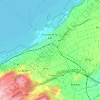
Name: Estavayer-le-Lac topographic map, elevation, terrain.
Average elevation: 1,493 ft
Minimum elevation: 1,385 ft
Maximum elevation: 2,005 ft
Make a donation
Gear up for your next adventure:
As an Amazon Associate, this site earns from qualifying purchases at no extra cost to you.
Other topographic maps
Click on a map to view its topography, its elevation and its terrain.
Forel
Switzerland > Fribourg > District de la Broye > Estavayer > Vernay > Forel
Average elevation: 1,503 ft