
Make a donation
Gear up for your next adventure:
As an Amazon Associate, this site earns from qualifying purchases at no extra cost to you.
Cerro Solo topographic map
Click on the map to display elevation.
Make a donation
Gear up for your next adventure:
As an Amazon Associate, this site earns from qualifying purchases at no extra cost to you.
About this map
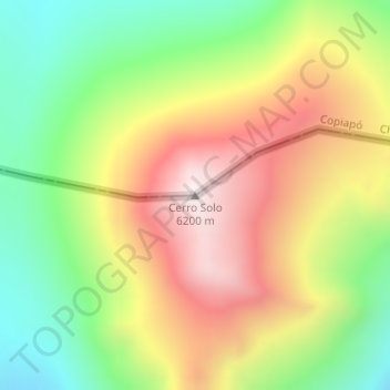
Name: Cerro Solo topographic map, elevation, terrain.
Average elevation: 18,852 ft
Minimum elevation: 17,503 ft
Maximum elevation: 20,364 ft
Make a donation
Gear up for your next adventure:
As an Amazon Associate, this site earns from qualifying purchases at no extra cost to you.
Other topographic maps
Click on a map to view its topography, its elevation and its terrain.
Salar de Maricunga
Chile > Región de Atacama > Provincia de Copiapó > Copiapó
Average elevation: 13,058 ft
Salar de Maricunga
Chile > Región de Atacama > Provincia de Copiapó > Copiapó
Average elevation: 13,058 ft
Parque Esmeralda
Chile > Región de Atacama > Provincia de Copiapó > Copiapó
Average elevation: 1,594 ft
Make a donation
Gear up for your next adventure:
As an Amazon Associate, this site earns from qualifying purchases at no extra cost to you.