
Thank you for supporting this site ❤️
Make a donation
Make a donation
Gear up for your next adventure:
As an Amazon Associate, this site earns from qualifying purchases at no extra cost to you.
Timizer topographic map
Click on the map to display elevation.
Thank you for supporting this site ❤️
Make a donation
Make a donation
Gear up for your next adventure:
As an Amazon Associate, this site earns from qualifying purchases at no extra cost to you.
About this map
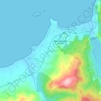
Name: Timizer topographic map, elevation, terrain.
Location: Timizer, El Aouana, Daïra El Aouana, Jijel, 18005, Algérie (36.76702 5.63779 36.80702 5.67779)
Average elevation: 125 ft
Minimum elevation: -3 ft
Maximum elevation: 702 ft
Thank you for supporting this site ❤️
Make a donation
Make a donation
Gear up for your next adventure:
As an Amazon Associate, this site earns from qualifying purchases at no extra cost to you.