Geolocate

Niceville topographic map

Click on the map to display elevation.

About this map

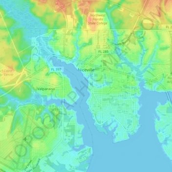
Name: Niceville topographic map, elevation, terrain.

Location: Niceville, Okaloosa County, Florida, United States (30.48439 -86.50630 30.53507 -86.41805)

Average elevation: 39 ft

Minimum elevation: -10 ft

Maximum elevation: 135 ft

Okaloosa County trails, hiking, mountain biking, running and outdoor activities

Other topographic maps

Click on a map to view its topography, its elevation and its terrain.

Dana Point

United States > Florida > Okaloosa County > Niceville

Average elevation: 7 ft

Holt

United States > Florida > Okaloosa County

Average elevation: 174 ft

Ocean City

United States > Florida > Okaloosa County > Ocean City

Average elevation: 20 ft

Deerland

United States > Florida > Okaloosa County

Average elevation: 207 ft

Gear up for your next adventure:

🎒Waterproof Dry Bags - Keep your electronics and maps dry inside your pack
💧Water Filtration Bottles - Safely drink from streams and lakes while exploring
🔥Fast-Boil Camping Stoves - Efficient cooking systems for quick trail meals
📦Dry Bags Set - Waterproof storage for electronics and clothes
🔥Camping Stove - Portable stove for camping and backcountry cooking

As an Amazon Associate, this site earns from qualifying purchases at no extra cost to you.