
Make a donation
Gear up for your next adventure:
As an Amazon Associate, this site earns from qualifying purchases at no extra cost to you.
Soraluze topographic map
Click on the map to display elevation.
Make a donation
Gear up for your next adventure:
As an Amazon Associate, this site earns from qualifying purchases at no extra cost to you.
About this map
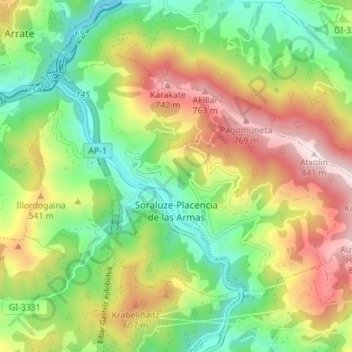
Name: Soraluze topographic map, elevation, terrain.
Average elevation: 1,214 ft
Minimum elevation: 177 ft
Maximum elevation: 2,707 ft
Make a donation
Gear up for your next adventure:
As an Amazon Associate, this site earns from qualifying purchases at no extra cost to you.
Other topographic maps
Click on a map to view its topography, its elevation and its terrain.
Karakate
Spain > Autonomous Community of the Basque Country > Debabarrena > Soraluze
Average elevation: 1,201 ft
Iruka
Spain > Autonomous Community of the Basque Country > Debabarrena > Eibar
Average elevation: 1,394 ft
Torrea
Spain > Autonomous Community of the Basque Country > Debabarrena > Eibar
Average elevation: 1,306 ft