
Make a donation
Gear up for your next adventure:
As an Amazon Associate, this site earns from qualifying purchases at no extra cost to you.
New Buffalo topographic map
Click on the map to display elevation.
Make a donation
Gear up for your next adventure:
As an Amazon Associate, this site earns from qualifying purchases at no extra cost to you.
About this map
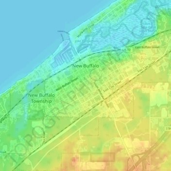
Name: New Buffalo topographic map, elevation, terrain.
Location: New Buffalo, Berrien County, Michigan, United States (41.77355 -86.76531 41.80859 -86.71924)
Average elevation: 627 ft
Minimum elevation: 574 ft
Maximum elevation: 699 ft
Berrien County trails, hiking, mountain biking, running and outdoor activities
Make a donation
Gear up for your next adventure:
As an Amazon Associate, this site earns from qualifying purchases at no extra cost to you.
Other topographic maps
Click on a map to view its topography, its elevation and its terrain.
Grand Mere State Park
United States > Michigan > Berrien County > Lincoln Charter Township
Average elevation: 607 ft
Make a donation
Gear up for your next adventure:
As an Amazon Associate, this site earns from qualifying purchases at no extra cost to you.
Grand Mere State Park
United States > Michigan > Berrien County > Lincoln Charter Township
Average elevation: 607 ft
Grand Mere State Park
United States > Michigan > Berrien County > Stevensville
Average elevation: 607 ft
Grand Mere State Park
United States > Michigan > Berrien County > Stevensville
Average elevation: 607 ft
Make a donation
Gear up for your next adventure:
As an Amazon Associate, this site earns from qualifying purchases at no extra cost to you.
Make a donation
Gear up for your next adventure:
As an Amazon Associate, this site earns from qualifying purchases at no extra cost to you.