

Haiterbach topographic map
Click on the map to display elevation.
Haiterbach
The township of (Stadt) of Haiterbach is located at the southern tipof the district of Calw, along its border with the district of Freudenstadt to the south. Haiterbach is physically located in the greater Black Forest region and the Heckengäu, with some of its municipal area lying in the Upper Gäu [de] to the north and east. The landscape of Haiterbach's municipal area is defined by the Waldach and its tributaries. Elevation above sea level in the municipal area ranges from a high of 678 meters (2,224 ft) Normalnull (NN) to a low of 428 meters (1,404 ft) NN.
About this map
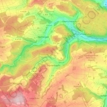
Name: Haiterbach topographic map, elevation, terrain.
Average elevation: 1,847 ft
Minimum elevation: 1,332 ft
Maximum elevation: 2,290 ft
Other topographic maps
Click on a map to view its topography, its elevation and its terrain.
Affolter
Germany > Baden-Württemberg > Landkreis Calw > Nagold > Pfrondorf
Average elevation: 1,650 ft
Zieflensberg
Germany > Baden-Württemberg > Landkreis Calw > Bad Herrenalb > Zieflensberg
Average elevation: 2,192 ft
Bad Teinach
Germany > Baden-Württemberg > Landkreis Calw
The township (Stadt) of Bad Teinach-Zavelstein is located at the center of the district of Calw, in Baden-Württemberg, one of the 16 States of the Federal Republic of Germany. Bad Teinach-Zavelstein's municipal area rests upon the plateau of the Enz and Nagold rivers, a landscape defined by severe river…
Average elevation: 1,827 ft